Seismotectonics and seismotectonic hazard in Hungary
Abstract
The ultimate goal of the research project 2018-2.2.1-NKP-2018-00007, funded by the National Research, Development and Innovation Office, was to create the seismotectonic model of Hungary. The completed seismotectonic model is represented directly by two new national maps at a scale of 1:500.000: the seismotectonic and the seismotectonic hazard map of Hungary. These are the first maps of this type for the country. The new maps will serve as effective tools for various academic research projects, local and national earthquake hazard and risk assessments, strategic analyses including the entire country, and energy/infrastructure preparation/planning tasks. The main objective of the present paper is to introduce the new maps constructed in the framework of the research project.
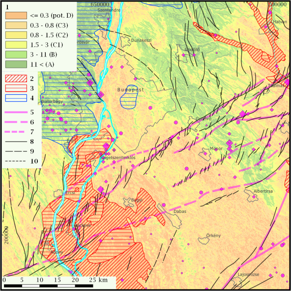
The new seismotectonic map synthesises the currently available seismological, tectonic and geodynamic knowledge in Hungary and provides also important input data (seismology, tectonics) for the seismotectonic hazard map. The latter one presents information for professionals and the society on the seismological characteristics and the potential for near-surface fault displacements of a given area. This information is complemented by the mapped elements of the Eurocode 8 soil classes, which show the potential for earthquake amplification effects due to the local geological nearsurface features. It should be emphasized, however, that the new national seismotectonic hazard map does not replace the need for carefully planned and executed local geophysical measurements and associated engineering geological investigations prior to a specific critical infrastructure or energetic project, which are essential to determine accurately the level of local seismotectonic hazard and to plan earthquake-proof buildings. The results of future seismological, tectonic and engineering geological studies will certainly refine and, where appropriate, modify our present knowledge of the hazard.