A regional Alpine graphite décollement level beneath the NW Pannonian Basin
Abstract
The so-called Transdanubian Conductivity Anomaly (TCA) of the Hungarian part of the NW Pannonian Basin has been well known for more than five decades. The exceptionally low resistivity (i.e. 1–2 Ωm) zone has a very large areal extent (on the order a few thousand km2) and it is an entirely subsurface anomaly occurring at depth between circa 3–15 km, with no corresponding outcrops. Various geological explanations of this enigmatic crustal-scale geophysical anomaly range from invoking sub-horizontal Alpine nappe contacts to sub-vertical dikes with graphite and/or saline fluid content. Only one possible analogue outcrop area was considered for the high conductivity anomaly so far, namely the Drauzug/Gailtal area of the Eastern Alps in Austria, some 300 km to the West from the TCA area.
Previous attempts to find correspondence between the TCA and prominent seismic reflectors seen on 2D seismic reflection profiles were based on data acquired by research institutions. This study systematically correlates, for the first time, the TCA with 2D industry seismic reflection data in the same area. Our new results show a very strong correlation between the subsurface extent and location of the TCA with various sub-horizontally oriented Cretaceous Alpine nappe surfaces. In addition, we draw on the latest structural correlation of the Alpine nappe stack of the Transdanubian Range with its proper tectonic counterpart in the Eastern Alps.
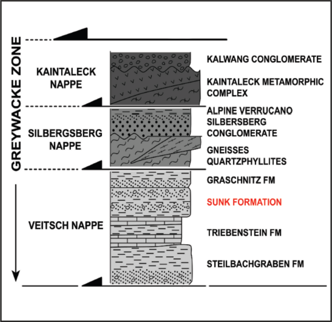
At the southern edge of the Upper Austroalpine units in northern Styria, in the Veitsch Nappe of the Greywacke Zone, numerous graphite localities are known historically. These laterally extensive graphite units in NW Styria formed as the result of greenschist-grade metamorphism of a Carboniferous coal sequence during the Cretaceous. For the first time, we describe here one well penetration of possibly age-equivalent graphitic units in NW Hungary. Correlation of the magnetotelluric anomaly with the distinct reflection seismic signature suggests that the same Palaeozoic graphitebearing Upper Austroalpine units should be present at 3–15 km depth in our study area.
Therefore we propose that the best explanation for the observed extent and geometry of the TCA is the presence of graphite in subhorizontal, tectonically thinned detachment surfaces at the base of the Upper Austroalpine nappe edifice of NW Hungary