Georeference of the first medium scale (M=1:144,000) geological map series of Hungary
Abstract
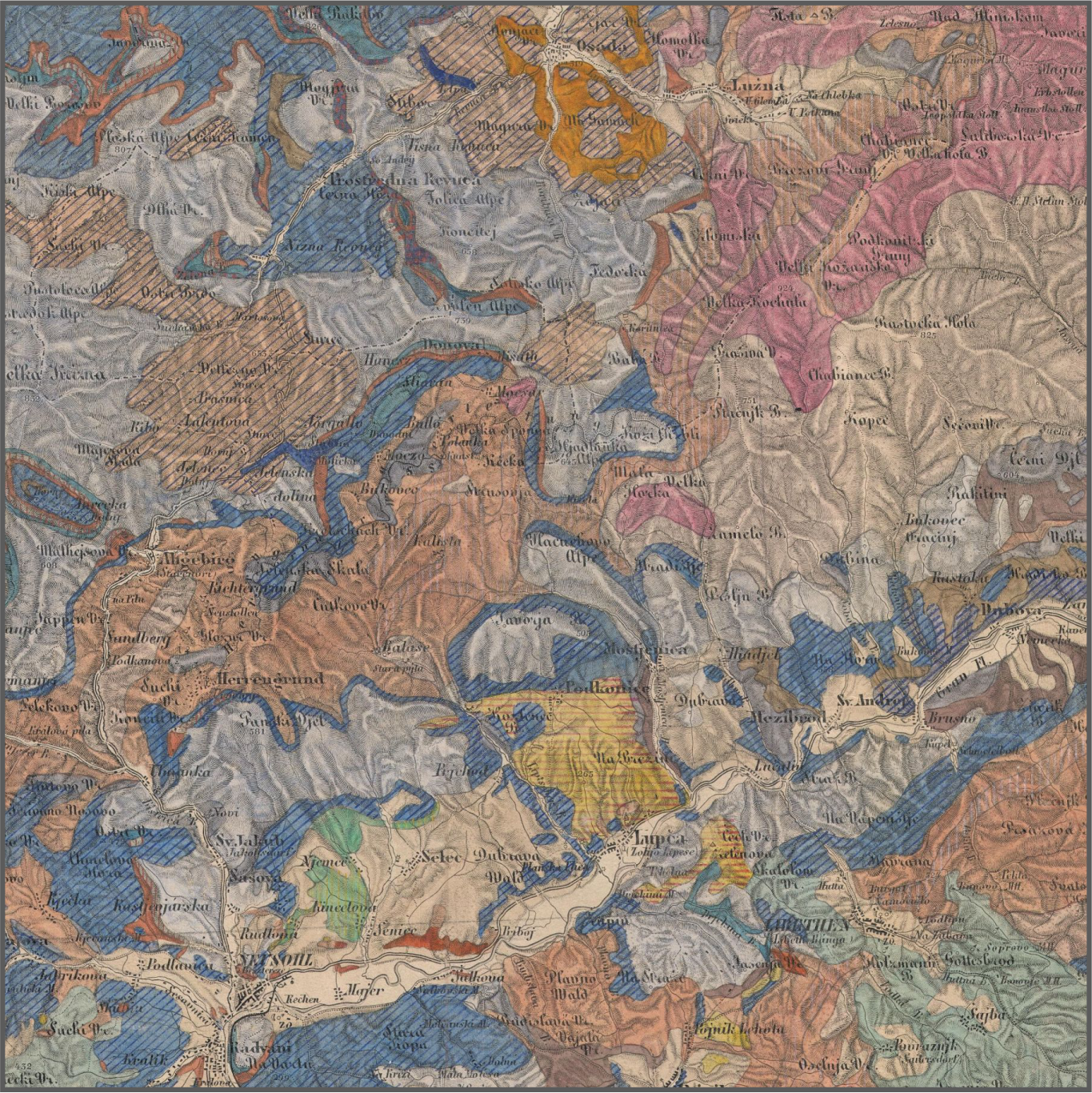
The geological mapping in Hungary was relied on the Royal Geological Institute of Hungary and its successor bodies since its foundation, during the last 150 years. The first systematic survey map of the Institute was the (uncompleted) 1:144,000 scale geological map of Hungary. Its topographic basis were the printed, so-called detailed sheets (Spezialkarte) of the second military survey of the Habsburg Empire. The geological pattern were drawn by manual coloring onto the topographic sheets. Many sheets of the map system can be found in two versions, some of them even in three versions of different coloring in the library of the institute. As the compilation of the sheets preceded the Bologna conference and the international agreement of the color system of geological maps, the colors of all mentioned versions differ from the ones of the usual modern geological maps. Here we provide the metadata, suitable for the georeference of the 1:144,000 sheets. Also, an example is provided, based on georeferenced, of the different patches of basalt-covered area of Balaton Highland, in the old and the modern geological maps.
References
ALBERT, G. (2019). The changing use-cases of medium and large-scale geological maps in Hungary — Proc. Int. Cartogr. Assoc. 2(4): 1-8. https://doi.org/10.5194/ica-proc-2-4-2019
BACHL-HOFMANN, C. (1999): Die Geologische Reichsanstalt von 1849 bis zum Ende des ersten Weltkriegs — In: BACHL-HOFMANN, C. et al. (szerk.): Die Geologische Bundesanstalt in Wien: 150 Jahre Geologie im Dienste Österreichs (1849–1999). Wien, Böhlau, pp. 55–77.
BARCZIKAYNÉ SZEILER R., HEGYINÉ RUSZNYÁK É., VIKOR ZS., OROSZ L., PENTELÉNYI A., SÍKHEGYI F., 2009: A földtani térképezés 140 éve — Térképválogatás a XVIII. századtól napjainkig. CD kiadvány, Magyar Állami Földtani Intézet.
BREZSNYÁNSZKY, K. 1996: Austro-Hungarian geological mapping before 1869 — Advances in Austrian–Hungarian Joint Geological Research, Budapest, 25–32.
BREZSNYÁNSZKY, K. & SÍKHEGYI, F.. 2007: Das Ungarische Geologische Institut, eine herausragende Werkstatt der thematischen Kartographie — Nova Acta Leopoldina 94, Nr. 349, pp. 49–69.
CAPELLINI, J. (szerk.) 1882: Congrès Géologique International, Compte Rendu, 2me Session, Bologne, 1881 — Impr. Fava et Garagnani, Bologne, 425 p.
FÜLÖP J., CSÁSZÁR G. HAAS J. & J. EDELÉNYI E. 1975: A rétegtani osztályozás, nevezéktan és gyakorlati alkalmazásuk irányelvei. Magyar Rétegtani Bizottság, Bp., 32 p.
GALAMBOS Cs. 2004: Földtani térképek felületi jelei — Geodézia és Kartográfia 56(7): 16–21.
GALAMBOS Cs. 2006: Digitális földtani térképek jelkulcsának kidolgozása integrált térinformatikai alkalmazások számára — Doktori (Ph. D.) értekezés, ELTE Földtudományi Doktori Iskola, Budapest, 139 o.
GALAMBOS, Cs. 2009: Development of color signs and projections of the Hungarian archive geological maps — Acta Geodaetica et Geophysica Hungarica 44(1): 131-140. doi: 10.1556/AGeod.44.2009.1.13https://doi.org/10.1556/ageod.44.2009.1.13
GALAMBOS, Cs. 2019: Estimation of projection and datum metadata of the early country maps of Hungary — AUTH CartoGeoLab 14: 268-274.
GALAMBOS Cs., NÉMETH, K., TIMÁR, G. & BERECZKI, L. 2019: Change of map representation of volcanic rocks of Balaton Highland (Hungary, Europe) from 19th century to nowadays — Geoscience Society of New Zealand miscellaneous publication 152: 202.
GYALOG L. & SÍKHEGYI F. (sorozatszerk.) 2005: Magyarország földtani térképe, M=1:100 000
– Magyar Állami Földtani Intézet kiadványa, Budapest.
HAIDINGER, W. 1845: Geognostische Übersichtskarte der österreichischen Monarchie, M=1:864.000 — Térkép, 9 db. kőnyomatos szelvény.
HAUER F. 1867: Geologische Uebersichtskarte der österreichische Monarchie — Jahrbuch der
k. k. Geologischen Reichsanstalt 17. Band, I. Heft, Wien, p. 1-2.
HAVAS G. 2005: Földtani térképek publikálása internetes környezetben — A Magyar Állami Földtani Intézet Évi Jelentése, 2004: 167-174.
HOFSTÄTTER, E. (1989). Beiträge zur Geschichte der österreichischen Landesaufnahmen, I. Teil — Bundesamt für Eich- und Vermessungwesen, Wien, 196 p.
HUBMANN, V B. & CERNAJSEK, T. 2005: 175 Jahre geologische Karte der Steiermark —
Mitteilungen des Naturwissenschaftlichen Vereines für Steiermark 134: 5-22.
INKEY, B. & SCHMIDT, S., 1880: Titkári közlemények — Földtani Értesítő 1(1–8): 149.
JANKÓ A. 2001: A második katonai felmérés — Hadtörténeti Közlemények 114: 103-129.
JANKÓ A. 2007: Magyarország katonai felmérései — Argumentum, Budapest, 196 p.
KORODI, E; HOFMANN, T. 2016: Historical cartographic overview and cartographic analysis of the geological map of Transylvania by Hauer (1861) — Geographia Technica 11(1): 44-53. doi: 10.21163/GT_2016.111.06https://doi.org/10.21163/gt_2016.111.06
KRETSCHMER, I., DÖRFLINGER, J. & WAWRIK, F. 2004: Österreichische Kartographie: Von den
Anfängen im 15. Jahrhundert bis zum 21. Jahrhundert — Wiener Schriften zur Geographie und Kartographie 15: 1-361.
MKFI [Magyar Királyi Földtani Intézet] 1911: A Magyar Kir. Földtani Intézet Könyvtárának betűrendes címjegyzéke valamint a térképeknek és rajzbeli ábrázolásoknak földrajzilag csoportosított jegyzéke – MKFI, Budapest, pp. 450–469.
PENTELÉNYI A. & SÍKHEGYI F. 2010: Hazai földtani térképeink topográfiai alapjai – MÁFI Évi Jelentése: 81-95.
STAUB M. & SZONTAGH T. (szerk.) 1886: A magyar bizottság jelentése a geologiai nomenclatura és térképjelzések egyveretűsége ügyében a nemzetközi geologiai kongresszus harmadik ülésszakára (Berlin, 1885) — Földtani Közlöny 16: 30-39.
TIMÁR G., 2007: A ferrói kezdőmeridián — Geodézia és Kartográfia 59(12): 3-7.
TIMÁR, G., MOLNÁR, G., SZÉKELY, B., BISZAK, S., VARGA, J. & JANKÓ, A. 2006: Digitized maps
of the Habsburg Empire – The map sheets of the second military survey and their georeferenced version — Arcanum, Budapest, 59 p.
TURCZI G. 2005: Földtani térmodell építése – adatbázisok az intra- és interneten — A Magyar Állami Földtani Intézet Évi Jelentése, 2004: 125-130.
VITÁLIS GY. 1992: A Magyar Állami Földtani Intézet kiadásában és kiadványaiban megjelent archív földtani térképek 1869-1919 — In: A Magyar Állami Földtani Intézet Évi Jelentése az 1990. évről p. 641 (pp. 637–651)